


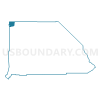
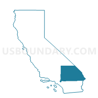
Voting District 10285, San Bernardino County, California
About
Outline

Summary
| Unique Area Identifier | 539484 |
| Name | Voting District 10285 |
| County | San Bernardino County |
| State | California |
| Area (square miles) | 117.05 |
| Land Area (square miles) | 116.30 |
| Water Area (square miles) | 0.75 |
| % of Land Area | 99.36 |
| % of Water Area | 0.64 |
| Latitude of the Internal Point | 35.71688630 |
| Longtitude of the Internal Point | -117.53857310 |
Maps

Graphs
Select a template below for downloading or customizing gragh for Voting District 10285, San Bernardino County, California


Neighbors
Neighoring Voting District (by Name) Neighboring Voting District on the Map
- Voting District 10020, Kern County, CA
- Voting District 10025, Kern County, CA
- Voting District 10030, Kern County, CA
- Voting District 10275, San Bernardino County, CA
- Voting District 10280, San Bernardino County, CA
- Voting District 10480, San Bernardino County, CA
- Voting District 10505, San Bernardino County, CA
- Voting District 50120, Inyo County, CA
- Voting District 50125, Inyo County, CA
Top 10 Neighboring County Subdivision (by Population) Neighboring County Subdivision on the Map
- East Kern CCD, Kern County, CA (78,648)
- Lone Pine CCD, Inyo County, CA (2,613)
- Searles Valley CCD, San Bernardino County, CA (2,174)
Top 10 Neighboring Place (by Population) Neighboring Place on the Map
Top 10 Neighboring Unified School District (by Population) Neighboring Unified School District on the Map
- Sierra Sands Unified School District, CA (35,267)
- Lone Pine Unified School District, CA (2,549)
- Trona Joint Unified School District, CA (1,885)
Top 10 Neighboring State Legislative District Lower Chamber (by Population) Neighboring State Legislative District Lower Chamber on the Map
Top 10 Neighboring State Legislative District Upper Chamber (by Population) Neighboring State Legislative District Upper Chamber on the Map
Top 10 Neighboring 111th Congressional District (by Population) Neighboring 111th Congressional District on the Map
Top 10 Neighboring Census Tract (by Population) Neighboring Census Tract on the Map
- Census Tract 8, Inyo County, CA (3,378)
- Census Tract 89.01, San Bernardino County, CA (2,174)
- Census Tract 53, Kern County, CA (2,139)